2.25.2006

Old US 80


I think I'm in the middle of nowhere. In the desert. But I'm still pedaling....


Actually I'm about 50 miles due north of Organ Pipe Cactus National Monument. I'm not going that way, though, so I'll have to admire the cacti along the roadsides where I am.

2.21.2006

East from Yuma

I'm cycling through some hot, dry country heading directly east from Yuma, Arizona. I'm just south of the U.S. Army Yuma Proving Ground.

US Army Yuma Proving Ground (USAYPG) is a general-purpose desert environmental test facility. It offers climate and terrain similar to major desert areas worldwide. YPG is primarily involved in developmental and operational test of artillery weapons and ammunition, aircraft armament systems, mobility equipment, and air delivery systems.

Located adjacent to the Colorado River in the Sonora Desert of Southwest Arizona, it's one of the hottest and driest areas in the nation. Larger in size than the state of Rhode Island, YPG encompasses more than 1,300 square miles. Yuma Proving Ground is 25 miles north of the city of Yuma, Arizona.

Yuma Proving Ground has an annual average of 350 sunny days, the air is sparkling clear and the average rainfall amounts to about three inches. This, plus the proving ground's excellent test facilities and staff of engineers, scientists and technicians, combine to offer to our customers an outstanding opportunity to test a large variety of materiel and equipment. An average of 100 tests are ongoing at any given time.

Modern military equipment testing in Yuma can be traced back to 1943, when the U.S. Army Corps of Engineers opened the Yuma Test Branch. The test site was located on the Colorado River below Imperial Dam for the purpose of testing new bridge designs, boats, vehicles, and well-drilling equipment for the Allied Armies of the Second World War. Supervisors of the dam regulated the flow of water, which provided ideal conditions for testing bridges and boats. Much of the test branch construction was performed by Italian prisoners of war.

The area was also a portion of General George Patton's California-Arizona Maneuver Area, used to train soldiers for service in World War II's North African desert campaigns.

2.15.2006

Almost at Duncan


My swimming from the last week puts me within sight of the bridge into Duncan.

Total mileage: 61.2km
http://www.gmap-pedometer.com/?r=22870

2.14.2006

MY THIRD STATE!!


Whooo! I'm into Nevada! Here's where I am, but other than showing you, I can't tell you where I am. There are no nearby towns or landmarks. The roads I'm taking aren't in the atlasn nor are they numbered on the map at G-Maps, and they don't even show up unless you zoom in close. I crossed a bridge over Middle Alkali Lake in northeastern CA just before the CA/NV state line, but could find nothing about it on the internet other than at some sites about water quality, which I suspect isn't great, given the name of the lake. So I'm just following my nose without any particular plan, just heading generally east-southeast, and eventually I'll have to come to something!

My mileage is now 416.2 miles, not bad for just 6 weeks, considering that up until 2 weeks ago I wasn't riding much. I've gone nearly 300 miles in the last 2 weeks. I never in my wildest dreams anticipated doing this kind of mileage at this time of year!

Thank Jefferson Davis

Jefferson Davis is one of the people whom we have to thank for the chunk of land on which I'm riding today. He was Secretary of War in 1848, when he convinced President Franklin Pierce to send James Gadsden to Mexico to negotiate the land purchase. This area later became Confederate territory during the Civil War, when Jefferson Davis served as President of the Confederate States of America.

I just passed through the Town of Wellton, Arizona. "Wellton (originally Well Town) was named for the time water wells were drilled to service the Southern Pacific Railroad. Most areas were settled in the 1860's as the need arose for stations to serve the Butterfield Overland Mail stagecoaches. With the railroads eventually supplanting the stagecoach lines in the 1870's, several communities were established (Tacna and Wellton) to provide water facilities for the old steam-powered engines. As the stagecoach gave way to the railroad, so the railroad gave way to the automobile. Though rail service is still maintained through Wellton-Mohawk Valley, the current economic livelihood is based on agriculture."

2.11.2006

Into Yuma, Arizona

A new state! I'll be in Arizona for quite a while.

"Located at the point where the Gila and Colorado Rivers converge, Yuma originated as a major transportation hub, as goods came from the west coast and were shipped up river. Since prehistoric times, Yuma has been the best site for crossing the Colorado River - Spanish conquistadors traveled this route in the 1500's and the only Ocean to Ocean bridge was constructed here in 1920, linking the Eastern U.S. and the West Coast." It's the 3rd fastest growing area in the U.S.

Fort Yuma was originally built on the ground of the original Concepción Mission where Father Garces was massacred by Yuma Indians in 1781.

Today's weather: High of 76*F, 9% humidity, now THIS is the ultimate cycling weather, as long as I drink plenty of fluids!

Today I'm also entering the land area of the Gadsden Purchase of 1853, but I'll write more about that as I ride along, since I'll be here for a while.

2.10.2006

40 MORE MILES


40.3, actually, bringing my total for the year and this trip to 316.2. I'm on small local roads in NE California, just passed Clear Lake Reservoir with its wildlife refuge. The refuge itself is not accessible except during specified hunting seasons, but the road is open, and I'm heading for the larger Goose Lake. I'm just kind of following the roads as I come to them, then checking the map to see where I am. Here's my progress up to now.

2.09.2006

Last stop in California

I made up 28.7 miles between today and a short ride yesterday, so I've crossed the California portion of the desert faster than I expected. I'll stay tonight just west of Yuma, still in the very southeast corner of California.

In the early 20th century, the only way to make a road across this sandy soil in this part of the country was to build plank roads like these. A few still exist as remnants of the early days of automobiles. The road I cycled on was nearly as bumpy.

I'm not far from Araz Junction, along the Southern Pacific Railway. Nearby are the ruins of Araz stagecoach stop, from the Butterfield stagecoach route. I hear there's a homeless encampment north of the tracks, I'd better be careful here.

Back to the roads

Everyone has recovered from their nasty colds so I get to dive back into the pool. Monday I surprised myself with 1600m (usually I manage 1400-1500). Wednesday I discovered (once again) that it's the second day back in the pool that hurts! I squeaked out 1350m (I did also arrive late for class).

My total distance is 56.85km, which puts me just south of Duncan in the Cowichan Reserve. (I'll describe the previous spots on the trip in another post.)

The view from my *bike* looks pretty much like this:


But I may have to stop for the afternoon after enjoying a few wine tastings:

2.07.2006

I'M GLAD I CAME THIS WAY!


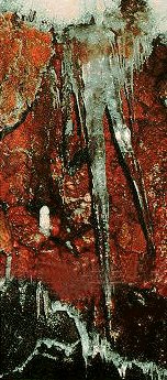
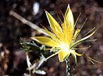
Wow. Lava Beds National Monument is beautiful. Here is a look at formations inside one of the lava-tube cavs; a Blazing Start pushing up through lava rocks; and a distant show shot.

Plus, I get a ride through northern California, which hadn't been in my original plan. This is why I change plans midstream all the time!


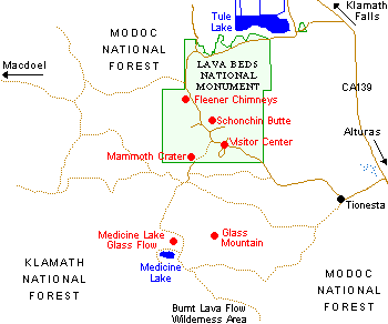
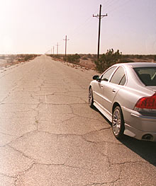
The map isn't too clear. The road to the east of the park, CA 139, is what I'm currently traveling. It's a nice road with hardly any traffic.

Overall statistics for Route 139:
Total Length (1995): 122 miles
Average Daily Traffic (1992): 500 to 6,800
Milage Classification: Rural: 121; Sm. Urban: 1; Urbanized: 0.
Previous Federal Aid Milage: FAP: 122 mi.
Functional Classification: Prin. Arterial: 56 mi; Minor Arterial: 66 mi.
Counties Traversed: Lassen, Modoc, Siskiyou.

I'll keep heading south on 139, to 299 East, then 395 South. After that I'll have to see what the prospects are for roads going east into Nevada, avoiding big cities and freeways, as well as dirt roads.

Yesterday was a 75-mile ride. Nancy -- the total you have for me is more than the one I have for myself. I'll take yours! I think I've screwed mine up mapping and re-mapping on G-Maps.

Here's my route and progress so far.

2.06.2006

Through the desert toward Yuma

I'm heading out into the desert now, along the Interstate 8 frontage road. I'm accumulating mileage slowly and it will take me a while to make it across the border into Arizona and to arrive in Yuma. I sure hope I can find a cold margarita there when I arrive. There's not too much of anything out on this road right now.

I'll post my latest position map here and update it for the next few days as the scenery will change slowly.

I'm on what is called the Evan Hewes Highway, which was named after an official of the Imperial Irrigation District. It hasn't been repaved in years, which makes it a little hard on my tires.

2.04.2006

NEW ROUTE PLANS

Instead of going back up north from Crater Lake to the main road directly east, I'm going to keep heading south into California. I'll have to turn south eventually and I've already been through the northern states east of Oregon. I've decided to head for, guess where, Panama City Beach (why not? That's where I'm running to, as well...) According to Geobytes Distance Calculator it would be 2284 miles as the crow flies. It will be farther by road. So out of Crater Lake National Park, I'm taking Rte. 62, then turning onto 39, which becomes 139 after the CA state line. This road goes past Lava Beds National Park and through Modoc National Forest, where there are lots of outdoor-activity choices between biking days. Hiking, and running on the rail-trails, are the most likely for me.

2.02.2006

Rolling past Imperial and El Centro

My bike segments are fairly short these weekdays. 22.5 miles added to my total. I'm still going through heavily irrigated agricultural land. I've passed just to the east of Imperial and El Centro, California, and I've turned east again on a small road paralleling Interstate 8. I'll be shadowing I-8 for quite a while now, but trying to stick to the small sideroads to avoid the blast of the enormous eighteen-wheelers.

Near Imperial, tomorrow is the 67th Annual Niland Tomato Festival!! And in Imperial, they're having stock car racing on Sunday. Another event that I will miss, since I'll be pedaling eastward.

Despite the presence of the town of Imperial next door, El Centro is actually the county seat of Imperial County with a population of about 38,000. They have recently adopted Howdy the Owl as their town mascot.

El Centro, starting in the 1940s, was the shipping center for vegetables in the south end of the Imperial Valley. The principal industries revolved around agriculture – fruit and vegetable packing and shipping, ice plants, a flax fiber plant, box factories, and concrete pipe and brick yards. Imperial County became one of the most agriculturally productive areas in the country and today more than 35 growers and shippers still operate in El Centro.

Finally, toward the end of the day, I passed through Holtville, a town of about 6000 population. In summer it has an average daily temperature of 105*F, so I'm glad I'm going through in the winter when the temperatures are comfortably in the 70s and 80s. On the next leg I'll pass out of the green irrigated areas into the starkly contrasting desert.