3.26.2006

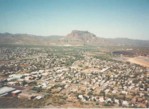
Near San Carlos Lake


I thought long and hard about which way to turn, and decided to stay on a southerly route, so I turned off to the right and I'm now heading in the direction of El Paso.

I'm now a little ways northeast of San Carlos Lake, one of eight lakes with desert surroundings created by damming rivers in the hills around Phoenix, and like the others it has quite a dramatic setting with the deep blue waters framed by gaunt, rocky, cactus-speckled mountains - in this case, the foothills of the Gila, Mescal and Santa Teresa ranges. The lake was formed by the Coolidge Dam (named after the 29th president) on the Gila River - the largest in south Arizona, this has its source in the Mogollon Mountains of west central New Mexico and once over the state border flows through a wide valley for over 80 miles. It then enters a much deeper canyon through the Mescal Mountains, the penultimate series of hills before the deserts of the southwest begin, hence the mouth of this ravine was selected as the site of the dam, which was completed in 1930.

Much of the land bordering the north and east shores is dusty, featureless and rather flat - gently undulating mounds with palo verde trees, assorted bushes and scattered, often somewhat unhealthy-looking saguaro, amongst which run numerous dry sandy washes.

3.22.2006

Through Miami


I had no idea that there was a Miami in Arizona, but here I am. Just shy of 500 miles for the journey.

Miami is located in the mountains of south central Arizona, approximately 75 miles east of Phoenix and 110 miles north of Tucson. In the 1860's the first non-Indians penetrated the region with expeditions organized by Anglo settlers and soldiers for the purpose of recovering stolen livestock from Apache raiders or conducting warfare against the Apaches. Silver mining started in the surrounding areas in the 1870's and interest in mining gold and silver was far greater than any other kinds of metal deposit.

It was not until the early 1880's when the price of silver dropped and the price of copper began to rise did the miners began to take an interest in copper deposits they had previously encountered in this region.
In 1906, the Miami Copper Company began working the claims in the Miami area and the demand for men to work in the mines increased. Most of the men traveled to work on foot (no public transportation), few miners could afford to keep horses, and these new mines were located 7 miles west of Globe, Arizona. The development of new large scale copper mines and the need to provide miners with convenient housing, shopping and places of amusement led to the founding of Miami, Arizona.

3.19.2006

Up past Superior

I'm heading up into the desert mountains east of the greater Phoenix-Tempe-Mesa area.

In November 1870 the first significant settlement by whites was made in what was later to be called Superior. In that month General George Stoneman, commanding officer of troops in Arizona against the Indians, built a small camp at the base of what the Mexicans called "Tordillo" Mountain. The soldiers began calling the butte "Picket Post," because they used it as a sentinel point to guard their settlement. At the foot of Picket Post they began constructing a pack-mule trail towards the Pinal Mountains.

The troops started their mule trail at "Infantry Camp" at the foot of Picket Post and then extended it into Picket Post Creek (later called Queen Creek). The trail then crossed Devil's
Canyon (named by the troops) and halted at a post they intended to build in what was then called "Mason's Valley" (later, Camp Pinal). The valley area is now known as "Top-of-the-World" or "Sutton's Summit."

By April 1871 the mule trail and post were both completed. General Stoneman planned on making Camp Pinal his headquarters, but the project was abandoned after General George Crook replaced General Stoneman because of the Camp Grant Massacre of April 1871. By
August of that year General Crook abandoned the post, and only the mule trail was left to indicate the intended ambitious presence of U.S. soldiers.

Even today the only physical reminder of the early military history of the Superior region is the old mule trail. It was dubbed "Stoneman's Grade" by the troops and can still be seen across the gorge of Queen Creek from Highway 60. It was quite an engineering feat, but it takes sharp
eyes to recognize it today.

There is, however, still another, if not physical, reminder of the early presence U.S. troops in the region. The origins of the "Apache Leap" legend can be traced to these troops. Although no official record exists of a skirmish between troops and Indians at what is now called Apache Leap, it is very likely that the legend has basis in fact. The legend relates that Apache warriors were trapped on the large rock ledge by cavalry troops from Camp Pinal. Rather than
surrender, however, about 75 of the warriors leaped off the cliff to their deaths. It was because of this incident that the cliff became known as "Apache Leap." Fragments of translucent obsidian embedded in perlite that can be found in abundance not far from the cliff are often called "Apache Tears" by residents of Arizona, in reference to the legend.

3.17.2006

Past Ellie's place

I cycled past Ellie's winter homestead today but I didn't see her! She must still be having fun with the extended family somewhere. Gosh, I haven't seen either her or Dianne around here for over a month now! I hope they're okay!

I continued on my way eastward out of town, through Apache Junction.

The history of modern day Apache Junction actually began in 1921, when Governor George P. Hunt, Arizona's first governor, recommended the construction of the Globe-Phoenix Highway which eventually linked the Salt River Valley with the mineral-rich Globe-Miami copper mining district with a modern surfaced highway. The Apache Trail soon became obsolete after the construction of the Globe-Phoenix Highway. After 1921 the Apache Trail served as a tourist route and a haul road for the Salt River Water Users Association.

3.14.2006

Ellie!?

I'm almost there! I may get there tomorrow. Just about four miles to go!

3.13.2006

Through Phoenix


I made my way through downtown Phoenix, Arizona over the weekend. Solo, not in a big pace line like these fellows riding through there in the 1880s.

On April 10, 1874, President Grant issued a patent to Judge Alsap for the present site of Phoenix. The declaratory statement was filed at the Prescott Land Office on Feb. 15, 1872. Official entry was made at the Florence Land Office on Nov. 19, 1873. The total cost of the Phoenix Townsite of 320 acres was $550, including all expenses for services. In 1874, downtown lots were selling for $7 to $11 each. That year also marked the entry into Phoenix of the first telegraph line. Morris Goldwater was the first operator of this station, located in his father's store on the northwest corner of First and Jefferson streets. By 1875, there were 16 saloons, four dance halls, two monte banks and one faro table in Phoenix.

Sometime this week I'll be stopping by to visit with Ellie. It will be great to see her!

3.04.2006

Goodyear

I'm now approaching Goodyear. It has been, hasn't it!?

Yes, it's that Goodyear.

The town of Goodyear of today exists because of the cotton of yesteryear. It was part of the 16,000 acres purchased in 1917 for the Goodyear Tire and Rubber Company by junior executive Paul Litchfield. Cotton used to make rubber tires for airplanes in World War I was in short supply because foreign sources were in war torn countries or disease-ridden.

When Goodyear found that Arizona’s climate and soil was similar to foreign sources, the company sent Litchfield to purchase land. The small community that formed as a result of the Goodyear Farms cotton industry first became known as “Egypt” for the Egyptian cotton grown there and then, finally, was called “Goodyear.”

The community thrived as long as the cotton industry was strong. But after the war, cotton prices plummeted and Goodyear’s economy suffered. However, World War II brought a recovery in the early 1940’s when the Litchfield Naval Air Facility and the Goodyear Aircraft Corporation located here, employing as many as 7,500 people at one time. Dirigibles or “blimps” were built at the Goodyear Aircraft Corporation. After the war, the Naval Air Facility served as a storage base for thousands of World War II aircraft that were moth balled and salvaged. Then, in 1968, the Navy sold the airfield to the City of Phoenix which named it the Phoenix-Litchfield Airport. In 1986, it was renamed the Phoenix-Goodyear Airport.

The town of Goodyear was incorporated as a city in November 1946. At that time, the town had 151 homes, 250 apartments, a grocery store, drug store, barber shop, beauty shop and service station. Today it's a rapidly-growing bedroom community for Phoenix.

3.01.2006

Gila Bend

Woo hoo! Time to actually take a turn! It's been a long ride through the desert, with more to go, but finally I'm seeing some turning action!

I'm now in Gila Bend, Arizona, branching off of Interstate 8 and heading north to end up just to the west of Phoenix.

The town website says: "Gila (pronounced "hee-la") Bend, named for the sharp bend in the Gila River. It is located near a prehistoric Hohokan Indian Village which Farther Eusebio Francisco Kino visited in 1699. Kino found the fertile banks of the Gila River had been abandoned by an early Indian tribe call the Opas, who had established a rancheria and raised two grain crops annually, irrigating from the Gila River. This same rancheria was visited by Spanish Captain Juan Bautista de Anza, commander of the Presidio at Tubac, and founder of the City of San Francisco, and Father Francisco Tomas Garces in 1774. Gila Bend has long been nicknamed the "Crossroads of the Southwest". For hundreds of years the area has been part of an important transportation route in the settling, development and growth of the Great Southwest. Gila Bend is ideally situated as the "center of a wheel" with spokes leading to and from all areas of the southwest."

"
Painted Rock Petroglyph Site, approximately 90 miles southwest of Phoenix, Arizona, and just west of Gila Bend, provides visitors the opportunity to view an ancient archaeological site containing hundreds of symbolic and artistic rock etchings, or "petroglyphs," produced centuries ago by prehistoric people. There are also inscriptions made by people who passed through during historic times. Many well-know events in Arizona history occurred near the Petroglyph Site, including the expedition of Juan Bautista de Anza that founded San Francisco, the Mormon Battalion and the Butterfield Overland Mail."