I'M GLAD I CAME THIS WAY!


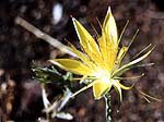
Wow. Lava Beds National Monument is beautiful. Here is a look at formations inside one of the lava-tube cavs; a Blazing Start pushing up through lava rocks; and a distant show shot.
Plus, I get a ride through northern California, which hadn't been in my original plan. This is why I change plans midstream all the time!

The map isn't too clear. The road to the east of the park, CA 139, is what I'm currently traveling. It's a nice road with hardly any traffic.
Overall statistics for Route 139:
Total Length (1995): 122 miles
Average Daily Traffic (1992): 500 to 6,800
Milage Classification: Rural: 121; Sm. Urban: 1; Urbanized: 0.
Previous Federal Aid Milage: FAP: 122 mi.
Functional Classification: Prin. Arterial: 56 mi; Minor Arterial: 66 mi.
Counties Traversed: Lassen, Modoc, Siskiyou.
I'll keep heading south on 139, to 299 East, then 395 South. After that I'll have to see what the prospects are for roads going east into Nevada, avoiding big cities and freeways, as well as dirt roads.
Yesterday was a 75-mile ride. Nancy -- the total you have for me is more than the one I have for myself. I'll take yours! I think I've screwed mine up mapping and re-mapping on G-Maps.
Here's my route and progress so far.

<< Home