1.31.2006

South towards Mexico

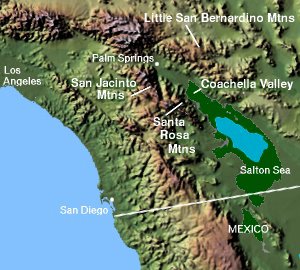
I'm heading south a little ways now, through the vast network of irrigated fields southeast of the Salton Sea. I'm taking this route in preference to many days of riding across the desert, the other northerly option heading east that I decided against.

First I rode through the town of Westmorland, California (population 2131), a quiet village which is about 80% people of Hispanic descent.

Then I passed through the nearby City of Brawley, California, which is about ten times bigger. The city is host of the annual Cattle Call celebration: "What began as a salute to the cattle industry - then the largest agricultural enterprise in the region - has evolved into an all-encompassing community celebration. More than 50,000 people travel to Brawley and nearby cities by car, motorhome and bus and stay for weeks - or just a day - 
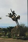
to attend a potpourri of events, large and small, ranging from a Bluegrass Festival and a Chili Cook-Off to the Grand Parade and one of the three rodeo performances."

Alas, I'm either too late, or too early, since Cattle Call is held in November, and I must be moving on! I'm now heading south, and I'll be facing into the winter sun for the next ride or two. Fortunately the weather here is mild now, with daily highs in the mid-70s.

A new route saved

Thanks to the G-maps upgrade, and Ellie keeping track of it for us, I re-constructed my cycling route to date and now can proudly display it here. This plot calls it 147.0 miles. (I'll obsessively add on that extra 0.8 the next time that I plot it.) Yay! I should be able to do updates starting from successive iterations of this map now.

G-MAPS UPGRADE!!!

Update bulletin at G-Maps: 1/28/06 Serverside Permalinks! Your routes will now be saved in a serverside database. This should mean that all you folks who have superlong routes that were getting cut off by browser limitations on the length of the querystring should see your problems resolved. Note that all existing permalinks and tinyurls will still work.

Whoo-HOOO! This makes it so much easier. I retraced my route including all the little bends in the roads I missed when marking the "short route" and found I'm up to 183 miles, not 171. YESS!! (I should keep track via my odometer, not the map.....)

Nancy -- what source did you use for your map showing your route to Mesa? I can't seem to copy a G-Maps image to my blog.

Heading east

The goal of the next leg of my cycling journey is to pedal eastward from the Salton Sea so that I can meet up with Ellie in her real location in Mesa, Arizona (or Apache Junction, a little further, if I pedal quickly), to arrive no later than March 25th. I want to enjoy some of those fun bike rides with her and the other badass babes! Mapquest suggested this southerly route of 280 miles, which seems to promise more frequent towns and sights to see and discuss than the less-traveled northerly route.

CRATER LAKE NATIONAL PARK


I'm so happy to have reached this place, my first "real" stopping/sightseeing place on my trip, and well worth it, too.

On the way down Rte. 97, I rode through the little town of Chemult, where my husband had a summer job as a surveyor in 1971, after our sophomore year at Michigan State University. I was home in Maryland. We had dated some during the year, and we wrote to each other during the summer, and fell in love by mail. So I loved going through Chemult and seeing where he was when he read my letters and wrote back.

I'm going to stay here for a few days and hike, jog some trails, and cruise on the bike... a rest stop in one of the most beautiful places on earth.

Here's my progress so far since starting. A whopping 171.8 miles....

1.29.2006

The Salton Sea

Welcome to Diane and Ellie, joining me here in logging their own cycling treks! It will be fun to have partners "alongside" even when they are thousands of miles away!

Today's ride took me to a new landmark: the Salton Sea. The Salton Sea is an inland saline lake, located in the Sonoran Desert in Southern California north of the Imperial Valley. The lake covers a surface area of 376 square miles (974 km²), making it the largest lake in California. However, it varies in dimensions due to changes in agricultural runoff. It averages 15 by 35 miles (24 by 56 km).

The sea falls within the territory of both Riverside County and Imperial County (I guess I entered Imperial County some time without realizing it). Like Death Valley, it is located below sea level, with the current surface of the Sea at approximately 225 ft (66 m) below sea level. The Sea is fed by the New, Whitewater, and Alamo rivers, as well as a number of minor agricultural drainage paths and creeks. The Salton Sea of today was created by accident in 1905, when heavy rainfall caused the Colorado River to swell and eventually breach an Imperial Valley dike. It took nearly two years to finally control the Colorado River’s flow into the Salton Sink and stop the flooding.

I took a side trip over to the coast, took a brief dip (without drinking any of the water, mind you), and continued on pedaling through heavily irrigated farmlands. Thankfully, it's also flat for a ways.

Total distance this year by the end of today: 147.8 miles. Maybe some day I'll get to the point that I can do this much distance in a day!!

1.28.2006

HI, GUYS....


I'm cycling with you now... or will be after I rest up from what I've decided is plain old overtraining syndrome. Started my trip with too much too fast too soon..... Wonder if I'll ever get out of Oregon?

1.23.2006

Ten more downhill

Why can't all my miles be downhill? I had a little wrong-shoes problem today, but I just wore my running shoes and pedaled on my Look pedals as if they were platforms. It did the job. Ten more screaming downhill miles* went quickly. Every downhill means another climb some time in the future, though.

I passed the road leading to Borrego Springs, but didn't turn off, since my supplies are still doing fine.

It's still hard to comprehend the distances out here - 111 miles of cycling, and I'm still in San Diego county. "Until the 1930s the Borrego Valley was one of the most isolated and least-known parts of San Diego County. Life there in the little homesteader community of Borego was still primitive. As late as 1940 there was not a single paved road in the valley, no electrical lines, no telephones. It was San Diego County's last frontier."

"
The Spanish word borrego . . . means a yearling lamb. Colloquially it also means a simpleton, or a fool." Fortunately, that doesn't apply to me, right? I'm just a-passin' through.


*And then another 7.5 of the same, to here.

Hello from another virtual cyclist


Hi! I'm Dianne from Calgary. I'll be cycling from Victoria, BC across Canada following the TransCanada highway. This will take a bit of time so I've decided to add my swimming and running/walking to the distance.


Mile Zero is just off the beach from the Strait of Juan de Fuca. The Royal Victoria Marathon route follows the coast right here, but I'll be heading inland and following the highway.


If you turn around at the Mile Zero marker, this is the view of the strait and the Olympic Mountains. Port Angeles, WA is straight over there somewhere.


Dianne

1.22.2006

15 miles of downhill

Now that is my kind of biking day! Downhill all the way, fifteen miles of wheeee!!

The views have been spectacular on the way down!

I've entered Anza-Borrego Desert State Park - with over 600,000 acres, it's the largest desert state park in the contiguous 48 states.

Today I also crossed County Highway S2, which I believe forms part of the Great Southern Overland Stagecoach Route of 1849.

Haloscan?

commenting and trackback have been added to this blog.

This resulted in all the old comments being stripped off, unfortunately, but it's still a pretty new blog. Sorry if your comment was a victim! Hopefully this will help reduce comment spam in the future here.

1.18.2006

Soon joining me....

Some of my fellow virtual travelers may be joining me here on the road soon! They are moving along different parts of the continent. We will do our best to keep our updates clear to you about where we each our in our journey!

I'll let them introduce themselves when they come on board.

Travel along with us!

Through the hills


Winding through the hills in southern California, another ten miles yesterday, and probably more today, heading east. These are part of the Santa Rosa Mountains, I believe.

I'm not very far north of Cuyamaca Rancho State Park, which was closed after extensive fire damage in 2003 but has now reopened.

Update: Plus another 3.6 miles. Now I'm here. This riding up the spine of the mountain ridge is slow going!

1.16.2006

Short day

7.5 miles further down the road. I'm winding my way up and up through dry brush-covered mountains.

This route takes me not far from the Sutherland Reservoir and along the outer borders of the Cleveland National Forest. "The wild shrub and tree-covered mountains are remnants of a landscape that at one time covered most of southern California. With the settling of missions, towns, cities, and suburbs, populated areas now surround the mountains. Natural areas for plants and animals have become smaller and smaller, and in some cases, have disappeared."

1.14.2006

Back on the road!

After a side trip on foot to do some running at Orlando, Florida, I'm back on the bike. 31.1 miles yesterday, heading east from Escondido, California.

I was able to stop on the way at the San Diego Wild Animal Park and enjoy watching the cheetahs and elephants.

I also visited en route the San Pasqual Battlefield State Historic Park, east of Escondido, which honors the soldiers who fought in the battle between the U.S. and Californio forces on December 6, 1846 in the midst of the Mexican-American War. Generals Stephen Kearny and Andres Pico both claimed victory. The battle was only one of the military encounters in California in the war, but it proved to be the bloodiest and most controversial as to the outcome. The park has been set aside, not as a monument to war, but as a reminder of the human ideals, actions and passions that can drive nations to bloodshed.

1.05.2006

I want you to know

I'm sure I'll be really tempted to get one of these, but I'm going to pedal every mile of the way myself.

Legoland

Another 7.5 miles today took me away from the Pacific coast and on the beginning of my long trek east. I'll stop and play a while at Legoland before I proceed.

Here's my new location.

If I wanted to stay another ten days, I could run the Carlsbad Marathon along this very road on January 15th, but alas, I must be on my way.

1.04.2006

Surf City


Oceanside towns don't get much better than this. I think I'll just stay in Carlsbad for a while and soak up some sun, maybe even get in an ocean swim, before I head on my way. Hey, can you blame me? I stopped along the Coast Highway at Easy Street, right near Friendly Place.

1.03.2006

On the road in Pacific Beach

Since it's San Diego, with America's mildest weather, naturally we're enjoying comfortable 65*F temperatures and 12 mph seaward winds as I begin my journey. I take one last trip way down to the end of the pier, past the folks fishing and look over the ocean, admiring the majestic view. The surfers bob in the waves below, sitting on their surfboards chatting and waiting for the next set of swells.

I head out first past my old friend Debbie's place in Pacific Beach on Beryl Street - oh, the times we had!!! - then up the coast, through the lovely hills of La Jolla and through Torrey Pines past the golf course, and then back down past Del Mar Racetrack, and into Carlsbad. I ran a wonderful half marathon there in 2002.

Here's my route for the first 26.4 miles.


My rear wheel in the Pacific

My virtual bike trip across America, inspired by Ellie, begins by dipping the rear wheel of my bike in the salty waters of the Pacific Ocean, adjacent to Crystal Pier, in the Pacific Beach neighborhood of San Diego, California.

Naturally I'm careful about getting sand on the bike, and so I must carefully pick it up after that little excursion and carry it over to the boardwalk at the head of Garnet Avenue for the beginning of my imaginary cross-country journey.

Many's the time that I have jogged along those sands, frolicked on the beach, and played in those waters. I'll ride down memory lane a little around the area before I strike out to the east.

Ride along with me. I'll be posting and mapping my updates regularly as I progress in my real-life equivalent-mileage cycling training for Ironman Florida in November, 2006.