1.16.2007

Ready to close

I finished out the year with around 2775 miles. That would be enough to get across the country if I picked the right route! So this blog accomplished its objective - got me going and headed in the right direction.

Thanks for reading along!

12.01.2006

Totally lost

I have no idea where I am on this cross-country trip. I have, however, accumulated 2667 miles cycling this year, with one month still to go. It's likely to be a small mileage month, though. We'll see how the weather cooperates.

The direct road distance from San Diego, California to Savannah, Georgia is 2389 miles, so with my side trips I suppose I'm somewhere around there in Georgia. Woot! Across the whole country!

9.20.2006

Still lost

I haven't mapped out my route yet, since the last time I attempted it gmaps blew up. I'm at 2191 miles, somewhere in the middle of the Deep South. Sorry I'm still lost....

Let's see, Savannah, Georgia is 2388 miles from San Diego, California along the direct road route, but I took some detours along the way. But that's only 197 miles more than I've traveled.

On the other hand, Panama City Beach, Florida (home of Ironman Florida) is 2074 miles from San Diego, California. So I should be somewhere around there or east of there.

8.27.2006

Finally out of Colorado!

Today's 70-mile ride finally took me out of Colorado into Kansas, in my "Tour d'Amerique." Click on the link to see my map so far!

Someday I hope to actually do this trip. Not necessarily Rte. 50, but definitely from sea to sea.

Judging by how straight the road has become recently, I'm in flatlands now, which is no doubt a distinct relief -- maybe I can start making better time now :-)

Total mileage so far this year: 1751.3 miles.

8.15.2006

Lost in space

I'm about 150 miles further east - but I can't seem to update the map, so I don't know exactly where I am. My odometer reads 1797.6 miles for the year right now, but I'll leave the count at the bottom header the same until I find a fix for my gmap. If necessary, I'll just start the track over in mid-Louisiana.

7.26.2006

Into Louisiana

Haven't updated in a while! I just passed through the corner of Arkansas, and now I'm in Louisiana. Two new states!

I'm just outside Shongaloo. What a great name! Shongaloo is a village in Webster Parish, Louisiana, United States. The population was 162 at the 2000 census.

I only have (roughly) 728 miles to reach Savannah, Georgia and the Atlantic Ocean, which I'll hopefully do within the next couple of months. Maybe when I get there I'll head back down to Panama City Beach and then work my way back up to Canada. Who knows?

7.05.2006

Nearly to Dallas

I'm just outside Jacksboro, Texas, northwest of Fort Worth, and I just passed Fort Richardson State Park.

Fort Richardson was established in November 1867. Fort Richardson was named in honor of General Israel B. Richardson, who died in the Battle of Antietam during the Civil War. The fort was the northernmost of a line of Federal Forts established after the Civil War. The soldiers arrived in Jacksboro in 1866 with orders to establish a fort at Buffalo Springs, 20 miles north of Jacksboro. Due to unhealthy conditions at Buffalo Springs and the constant Indian raids, the fort was abandoned. The soldiers returned to Jacksboro and eventually received orders to establish a fort on the South Bank of Lost Creek. Expeditions sent from Fort Richardson arrested Indians responsible for the Warren Wagon Train Massacre in 1871 and fought Comanches in Palo Duro Canyon. The Fort was abandoned in May 1878.

Ft. Richardson State Park, Historic Site & Lost Creek Reservoir State Trailway, located northwest of Fort Worth in Jack County, contains 454 acres. The property was acquired in 1968 from the City of Jacksboro and was opened to the public the same year.
6.17.2006

Post, Texas

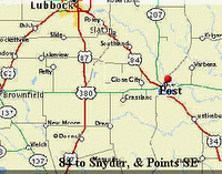
Just passed through the small town of Post, Texas, 41 miles southeast of Lubbock.

"Located at the foot of the majestic Caprock that separates the flat Llano Estacado from the rolling hills and canyons that mark the ranching area of West Texas, Post offers a unique history."

"Founded in 1907 by breakfast cereal magnate Charles Williams Post, as his "dream city". His vision drew him to one of the most beautiful locations in West Texas, where the head waters of both arms of the Brazos River join to outline the scenic Caprock escarpment, home of cattle, oil and cotton."


"The area is unmistakably cowboy country that offers a visual surprise of beauty as you approach from any direction. It is so completely different from the High Plains of Texas that you feel like you are in another part of the world."

"An Arts industry has developed in the original city buildings, fulfilling a dream of C.W. Post, of a rich cultural community. Post was awarded a "
Main Street City" designation in 1987."

"Downtown buildings having been restored and are now home to unique gift shops and stores. Post is easily reached on either U.S. 84 or 380 where you are always welcome and invited to stay and sit a spell."

6.06.2006

Brownfield, Texas

Into a new state! I'm now cycling along the flatlands of northern Texas, hoping as always for a steady tailwind.

Brownfield is at the junction of U.S. highways 62, 82, 380, and 385 and State Highway 137, forty miles southwest of Lubbock in central Terry County. In 1903 town promoters W. G. Hardin and A. F. Small arrived in Terry County planning to turn Small's few hundred dollars into thousands. The two men bought the county's center lot from A. M. (Dick) Brownfield and began to plat the site, giving every voter in the county a lot in order to enhance the town's chances of becoming the county seat; they named the town after a prominent ranching family. The founders donated one block each for the courthouse, the school, and churches. J. R. Hill, the first to arrive with his family, built Hill's Hotel, the first business establishment, on the north side of the square. On April 1, 1903, Hill opened the first post office in his hotel building and became the first postmaster. The settlers lived in tents, covered wagons, or dugouts until construction materials for houses could be hauled from Big Spring or Colorado City. A school was built, and since there was no money for a teacher or equipment it served as a dance hall, church, and general gathering place until 1905, when the first school term began.

5.21.2006

Abducted in Roswell

5.16.2006

Down from the mountains

I'm heading east from Ruidoso now, passing through the towns of Tinnie and Picacho. Um, I don't think they're on the Internet yet. The New Mexico Tourism Department has no entry for either of them. They do, however, have zip codes, so presumably the US Postal Service has heard of them.

Just to the north is Lincoln National Forest, the birthplace of the world-famous Smokey Bear, the living symbol of the campaign to prevent forest fires.

5.09.2006

Ruidoso Downs, New Mexico

I've gone nearly 900 miles in my virtual cycling trip now which puts me just outside Ruidoso Downs, New Mexico. The race track is the home of the All-American Quarter Horse Futurity, the richest quarter mile in sports, plus an excellent small Museum of the Horse.

4.28.2006

White sands

4.23.2006

MILESTONES


Today's 40.3-mile ride took my odometer over 2400 miles, and took my total mileage since New Year's over 800. Whoopee!! Here's my progress so far.

Near as I can figure, I am just west of Ely, NV, which looks like a fine place to check out. I am also nearly across NV itself. Crossing into Utah within my next 2 or 3 rides is going to be another major milestone.

Without intending to, I have stumbled upon a two-lane interstate highway that will take me all the way to Ocean City, past St. Michaels and Cambridge, MD, so I'll get to return Nancy's virtual visit :-) I have actually driven stretches of this road myself, in WV. And I'll tell you what, it's gonna be a climb when I get to that point. I've been there!! BUT I'll have to go DOWN to get to sea level, so it's not all bad! I didn't realize, when I got on this road in Nevada, that it was the same Rte. 50 I'm already familiar with in the East. To check it out, go here and click number 9. And check here to see all the neat stuff it passes in Nevada. This road and the website are going to make my virtual-trip blogging a whole lot easier!

The website, Road Trip USA, details a lot of Trans-USA trips on two-lane highways:

"Ready for a taste of the open road? Choose route numbers or names to access driving tours across more than 35,000 miles of classic blacktop. Then sit back and experience part of America—the small towns, funky attractions, roadside curiosities, and more—that the interstates have left behind."

Check it out if you want to plan such a trip -- by bike, car, motorcycle, or even on foot (you never know!)

There are two books mentioned at the site: Blue Highways by William Least Heat Moon, which I have read and thoroughly enjoyed (why I don't remember Rte. 50 from it is a mystery to me;) and the hard-copy of the website, Road Trip USA, by Jamie Jensen, which is sitting between 2 bookends on our dining table. (I can't say "dining room" because our trailer is all one room, except the bedroom.) It was in opening this book a couple days ago that I discovered the absolute perfection of Rte. 50 for what I am doing. Here we've had the book for 2 years and I've never really looked at it!! (Maybe because Steve plans all the trips...)

This may very well be the route to take WHEN (not "if") I/we actually do a coast-to-coast ride in real life.

Las Cruces, New Mexico

I'm just passing through the town of Las Cruces, New Mexico - as always, heading east.


Four hundred years ago, Don Juan de Oñate made his historic trek into what is now New Mexico in search of gold. In 1598, working on behalf of the King of Spain, Oñate and his entourage made their way through the great Pass of the North (modern-day El Paso) and then north to what would become Santa Fe. The route became known as the Camino Real. The company moved along the Rio Grande to ensure that they would have water as they passed through the desolate land. But eventually, land barriers forced the expedition away from the river and into the deadliest portion of the Camino Real now known as the Jornada del Muerto, or Journey of the Dead. Many men died of thirst along this stretch, both during Oñate's trek and on those that followed. Oñate's expedition marked the first major European colonization of the North American continent, years before Pilgrims landed at Plymouth Rock.

More than 150 years ago, United States Army Lt. Delos Bennett Sackett, using rawhide rope and stakes, plotted out 84 city blocks to form what is known today as Las Cruces, NM. Sackett came to the Mesilla Valley from Fort Gibson, Okla.During the summer of 1848, with the First Dragoon of Company H., his mission, along with the 87 other soldiers, was to protect small communities from Apache raids. These communities included El Paso (or Paso del Norte) and Doña Ana, a small village headed by alcalde Don Pablo Melendres.

By 1848, the Mexican War with the United States had ended with the signing of the Treaty of Guadalupe Hidalgo. That treaty, among other things, converted Doña Ana from Mexican to United States territory. Many settlers headed for the area, trying to claim rights to the undeeded land just acquired by the treaty. In an attempt to maintain order in Doña Ana, Don Pablo Melendres sought relief from the US Army to help in surveying and platting out a new town site. Using rugged equipment, Las Cruces, at least in concept, was born.